The Tagus River in Toledo, Spain
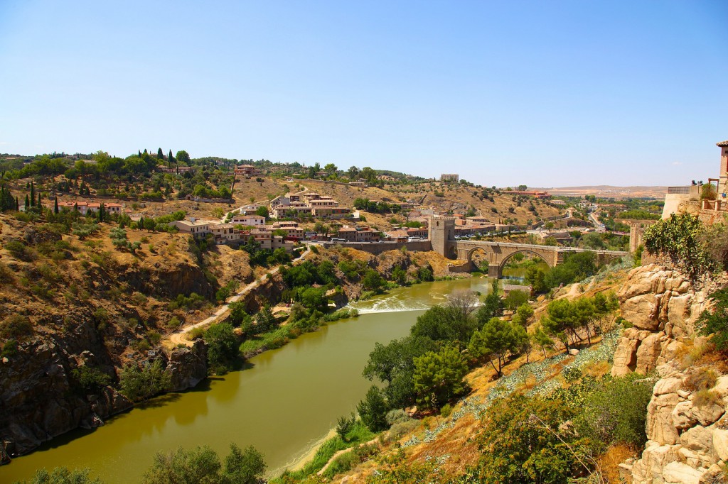
The Tagus (Tajo in Spanish, Tejo in Portuguese) is the longest river of the Iberian Peninsula, and Toledo is the city most closely tied to it: the old town sits on a rock inside a tight bend of the river. This post explains where the Tagus comes from and where it goes, how it shapes Toledo, where to walk along it and look at it, and how its water is used today.
The river in figures
According to the Confederación Hidrográfica del Tajo, the public body that manages the Spanish part of the basin, the Tagus is 1,092 km long. It rises in the Sierra de Albarracín, in the east of Spain, crosses the centre of the peninsula from east to west and reaches the Atlantic next to Lisbon, in the estuary known as the Mar de la Paja.
The basin is shared by two countries. The Spanish part covers about 55,781 km² and the Portuguese part about 25,666 km². In Spain it takes in land of five autonomous communities (Extremadura, Madrid, Castile and León, Aragon and Castile-La Mancha), and four provincial capitals lie inside it: Cáceres, Madrid, Guadalajara and Toledo. Almost the whole Madrid region drains into the Tagus.
The tributaries are uneven. Those on the right bank, such as the Jarama, Alberche, Tiétar and Alagón, come down from the Sistema Central and carry most of the water. Those on the left bank, many of them from the Montes de Toledo, are short and carry little. Rainfall in the central depression is low, and the basin authority notes that the lowest values are recorded around the city of Toledo.
How the Tagus shapes Toledo
Spain’s Ministry of Culture describes Toledo as standing on a high rock surrounded by a wide meander of the Tagus. The river closes the old town on three sides, and the city wall closes the rest. The historic centre inside this loop has been a UNESCO World Heritage Site since 1986.
Two old bridges cross the gorge. The Puente de Alcántara, on the east side, is of Roman origin and was rebuilt in the 10th century; its baroque arch dates from 1721. The Puente de San Martín, on the west side, already existed in the middle of the 14th century and has five pointed arches and a tower at each end. Both were declared National Monuments in 1921.
Toledo’s best-known painter used the same view. The city’s tourist office compares the panoramic route around the river with El Greco’s View and Plan of Toledo, which is shown in the Museo del Greco.
Walks and viewpoints
The Toledo tourist office lists several places to see the river:
- Senda ecológica: a footpath along the bank that runs around the historic centre at water level. It lets visitors see the natural setting of the city from the bank.
- Miradores del Valle: the viewpoints on the far bank with the classic panorama of the city. They are about 35 minutes on foot or 6 minutes by car from the centre, access is free, and the tourist train and many sightseeing buses stop there. The walk passes the Ermita de Nuestra Señora del Valle and the Cerro del Bú, where the first settlement of Toledo stood in the Bronze Age.
- Paseo del Tránsito: a small park in the Jewish quarter with a monument to El Greco and a view over the river valley.
- Parque Escolar Circo Romano: a pine park on the north side of the old town,, with the remains of a Roman circus of the 1st century and the nearest municipal summer swimming pool.
Spain’s official tourism site adds that visitors can cross the Tagus on a zipline and recommends the sunset from either bridge. For a half-day trip, the Barrancas de Burujón are cliffs carved by wind and water, 30 km from the city, which the tourist office recommends for birdwatching and sunsets.
Water, power and the Tagus-Segura transfer
The Tagus is one of the most heavily used rivers in Spain. The basin authority lists Madrid and its metropolitan area as the largest consumer of drinking water, followed by Guadalajara, Toledo, Talavera de la Reina and Cáceres. Madrid’s supply is managed by the Canal de Isabel II, mainly with reservoirs on the Jarama, Manzanares and Alberche, all of them tributaries of the Tagus.
The river also produces electricity. The largest hydroelectric plant in the basin is José María Oriol, at Alcántara in the province of Cáceres, with a capacity of about 915 MW, followed by Cedillo, Valdecañas and Torrejón, also in Cáceres. Two smaller plants on the Tagus, Azután and Castrejón, are in the province of Toledo.
Part of the water leaves the basin. The Tagus-Segura transfer takes water from the Entrepeñas and Buendía reservoirs, near the head of the river, to the Segura basin in south-east Spain for irrigation and drinking water, up to a legal maximum of 600 hm³ a year. A further 50 hm³ a year at most can go to the Guadiana basin. The idea was first raised in 1922, the project was taken up again in 1966, and the first water reached the Segura in 1979. The water is pumped up 250 metres from the Bolarque reservoir before it starts its journey.
The river carries less water than it used to. Counting from 1940, the average natural flow of the Spanish part of the basin is 9,604 hm³ a year; counting only from 1980, it falls to 8,515 hm³ a year. The basin authority publishes the hydrological plan, the drought plan and the current reservoir levels on its website.
Getting there and when to go
Toledo is less than 80 km from Madrid. According to the tourist office, Avant high-speed trains leave Madrid-Atocha about once an hour and take 25 minutes, and ALSA buses leave Plaza Elíptica every 30 minutes and take one hour on the direct service. From the railway station it is about 20 minutes on foot to the historic centre. A city bus ticket costs €1.40 and has to be paid in cash.
Summers are very hot and dry, especially from mid-June to September, so the riverside path is best walked early in the morning or towards evening.
Students who want more than a day trip can look at the Toledo city page or at the full list of schools in Spain.
More about: Toledo · All blog posts