El Río Manzanares, Madrid, Spain
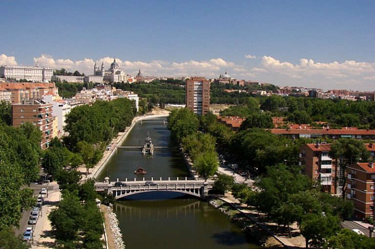
The Manzanares is the river of Madrid. It is a small river, but it links the mountains north of the city with the long riverside park that now runs through the capital. This post follows the river from its upper valley to the south of the city and gives the practical details for visiting the Madrid Río park, the historic bridges and the places connected with the painter Goya.
The upper valley: La Pedriza and Manzanares el Real
The river rises in the Sierra de Guadarrama. The Madrid regional law that protects its headwaters describes the upper basin as running from the source, in the area generally known as La Pedriza, to the north wall of the Monte de El Pardo. That law, of January 1985, created the Parque Regional de la Cuenca Alta del Manzanares, the first regional park in Spain. In 1993 UNESCO included it in its world network of biosphere reserves.
The rock landscape of La Pedriza, above the town of Manzanares el Real, is now part of the Parque Nacional de la Sierra de Guadarrama. The park’s La Pedriza visitor centre is about two kilometres from the town, which bus line 724 connects with the Plaza de Castilla interchange in Madrid. Bathing in the Manzanares is not allowed there. Beside the town lies the Santillana reservoir, a pleasant place for a walk. Reservoirs on the Manzanares, the Jarama and the Alberche provide most of the water that the public company Canal de Isabel II supplies to Madrid.
Further downstream the river crosses the Monte de El Pardo, and the flow that reaches the city comes from the El Pardo dam.
Madrid Río: the river in the city
The M-30 ring road used to run along both banks of the river in the city. Part of the road was moved underground, and the land above it became Madrid Río, a park about 10 kilometres long. The city’s tourist board describes it as a green corridor that connects the Casa de Campo, the Campo del Moro gardens, San Isidro park and the Manzanares linear park.
The river itself has been restored. According to the tourist board, water quality has improved, fish breed in the river again and the vegetation growing in the riverbed gives shelter to birds and amphibians. The river is now a wildlife corridor between the parks in the north-west of the city and those in the south-east.
The main things to see and do in Madrid Río are:
- The Salón de Pinos, a tree-lined walkway 6 kilometres long, with 17 play areas for children along it
- The Arganzuela park, the largest garden in Madrid Río at 23 hectares, with the Arganzuela footbridge, a spiral metal structure 274 metres long designed by the architect Dominique Perrault
- The city beach, three oval water features with jets and spray, which works only in summer, when the fountains run from 11am to 9pm
- Cycle paths, a skatepark, a climbing wall, football pitches and tennis and paddle tennis courts
- Matadero Madrid, the former slaughterhouse beside the river, now a cultural centre with free entry to its outdoor spaces
The Vicente Calderón stadium, home of Atlético de Madrid for more than fifty years, stood on the river bank. It has been demolished and a park, the Parque Atlético de Madrid, occupies the site.
South of the centre, the Manzanares linear park in the Usera district continues the green corridor. It surrounds the Caja Mágica tennis centre, and its highest point carries La Dama del Manzanares, a sculpture 13 metres high by Manolo Valdés that is dedicated to the river.
Historic bridges
The Puente de Segovia is the oldest bridge in Madrid. Work on it began in 1574. After the death of its first architect, Juan de Herrera took over the project. The bridge has nine semicircular arches of granite.
The Puente de Toledo is a Baroque bridge built between 1719 and 1724 and finished by Pedro de Ribera. It is now for pedestrians only. Two small pavilions at its centre hold statues of San Isidro and Santa María de la Cabeza.
The Puente del Rey dates from the early 19th century. At first only the king could use it, to cross from the Royal Palace to the Casa de Campo. It is now one of the main entrances to Madrid Río.
The river in Goya’s Madrid
Francisco de Goya painted the river bank more than once. His sketch The Meadow of San Isidro, kept at the Prado Museum, shows the people of Madrid on the meadow across the Manzanares, with the Royal Palace and the city’s skyline behind them. The meadow is still the setting of the San Isidro festivities each May.
Beside the river, near Príncipe Pío, stands the chapel of San Antonio de la Florida. Goya painted the frescoes of its dome at the end of the 18th century, and he has been buried in the chapel since 1919. Entry is free. In 2026 the chapel is open from Tuesday to Sunday, 9.30am to 8pm, with a shorter summer timetable from 15 June to 15 September. It is closed on Mondays.
Practical information
Madrid Río is an open public park; the tourist board lists no entry price or opening times for it. Metro stations along it include Príncipe Pío (lines 6 and 10), Puerta del Ángel (line 6), Marqués de Vadillo and Pirámides (line 5) and Legazpi (lines 3 and 6). Cercanías trains stop at Príncipe Pío and Pirámides, and the BiciMAD bike-share scheme has docking stations along the park.
At about 10 kilometres, the whole park is a walk of two to three hours. A shorter visit can start at Príncipe Pío, pass the Puente del Rey and the Puente de Segovia, and end at the Puente de Toledo. In spring 2026 the city council introduced audio guides in Spanish and English, reached by QR codes in the park.
For students
The riverside is one of the main places in Madrid to run, cycle or skate without traffic, and it costs nothing. Matadero Madrid has a cinema, exhibitions and a reading centre, and the park’s outdoor spaces are used for concerts and other events through the year.
More about: Madrid · All blog posts