Puente de Segovia, Madrid
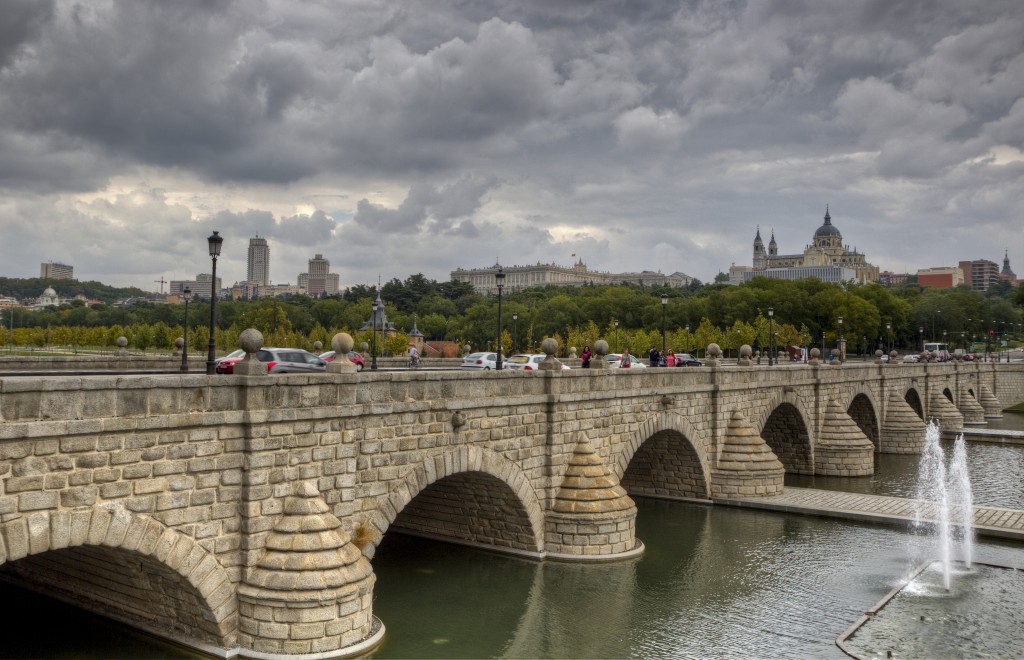
The Puente de Segovia is the oldest bridge still standing in Madrid. It carries Calle de Segovia over the Manzanares river on the old road to Segovia, and today it sits in the middle of the Madrid Río park. This post covers its history, what to look for in the stonework, and how to reach it.
A bridge for the new capital
Felipe II settled the court in Madrid in 1561, and the city needed a solid crossing on the road from Segovia, one of its main entrances. Earlier bridges on the spot, recorded since at least the 14th century, had not lasted. According to Madrid City Council’s heritage service, work began in 1574 by royal order under Gaspar de Vega, the king’s master of works, who got as far as the foundations of the main piers.
Vega died in 1577. The project passed to Juan de Herrera, the architect of the Monasterio de El Escorial, who drew a new design on the piers already begun. The bridge was practically finished in 1584. Madrid’s tourist office describes it as the first modern bridge in the city because Herrera gave it a level roadway instead of the humped profile of medieval bridges.
What to look for
- Nine arches: semicircular arches in granite ashlar. Because Herrera reused the existing piers, the spans differ, from 13.22 metres in the centre to 10.35 metres at the sides.
- Roman model: cushioned stonework and cutwaters that are pointed upstream and rounded downstream, with pilasters rising from them to the cornice.
- Granite balls: the plain parapet is topped by a row of stone spheres above the pilasters, a typical motif of the Herrerian style.
- Later additions: the side walls, ramps and basins at each end date from the 20th century and are not part of the original. With them the whole structure is 172 metres long.
Repairs, war and widening
The bridge was repaired many times, by architects such as José de Villarreal in 1648, Pedro de Ribera in 1721 and Ventura Rodríguez in 1775. An ornamental gate by Teodoro Ardemans once stood at one end and was later removed.
In November 1936, during the Spanish Civil War, the Republican side blew up the bridge to stop Franco’s troops entering Madrid. It was rebuilt after the war with changes. The engineer Vicente Olmos widened the deck from 8.65 to 31 metres by splitting the bridge lengthwise, moving the two faces apart and building a new structure between them. Between 1955 and 1960 Olmos also uncovered parts of the elevations that had been hidden when the Manzanares was canalised in 1915.
The bridge has been a Bien de Interés Cultural, Spain’s highest heritage listing, in the category of Monument since 1996. The M-30 ring road beside the river was put underground between 2004 and 2007, and the Madrid Río project then laid out ponds, fountains and paths around the bridge, with steps down to the water.
How to get there
There is no ticket and no timetable: the bridge is a public street and the park around it is open. Madrid’s tourist office lists these connections:
- Metro: Príncipe Pío (lines 6, 10 and R) and Puerta del Ángel (line 6)
- Cercanías suburban trains: Madrid-Príncipe Pío
- City buses: among others 25, 31, 33, 36, 39, 41, 50, 62, 65, 138 and 148
- BiciMAD bike-share docks at Calle de Segovia 45, Paseo Virgen del Puerto 27 and Plaza Puerta del Ángel 3
The best view of the arches is from the riverside paths of Madrid Río, upstream or downstream of the bridge, not from the roadway.
For students
The bridge is a free stop on a walk or bike ride along Madrid Río, the leisure and cultural strip that runs parallel to the river. It pairs well with the post on the Manzanares river and with Príncipe Pío station, the nearest transport hub. Schools and universities in the city are listed on the Madrid city page.
More about: Madrid · All blog posts